
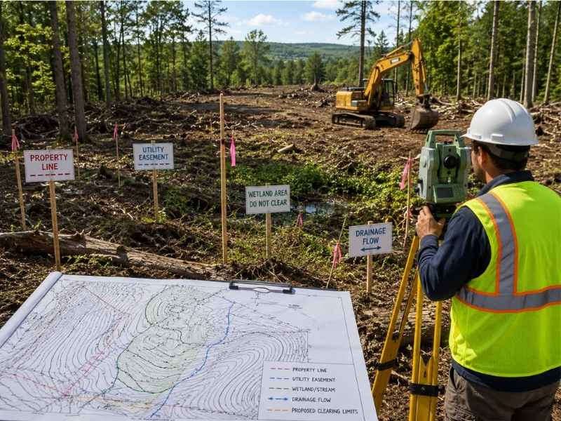
Clearing land on a rural or wooded property feels straightforward. You want the trees gone and the land open. But clearing without a surveyor leads to expensive problems. You might cut trees that belong to a neighbor. You might damage underground utilities and create dangerous situations. You might violate environmental laws or easement restrictions. A surveyor identifies these hidden issues before clearing work begins. Calling a surveyor before clearing protects your property, your wallet, and your legal standing.
Why a Surveyor Finds Property Lines Hidden Under Trees and Brush
You cannot clear land safely without knowing where your property ends and your neighbor’s starts. Trees and heavy brush hide property lines completely. A surveyor locates these lines before any clearing work begins. This prevents you from cutting trees that belong to the neighbor or accidentally damaging their property.
How a Surveyor Locates Boundary Lines Under Vegetation
Surveyors use property records and physical evidence to find boundaries. They look for old markers, stakes, or blazes on trees that mark the original survey. They measure from known reference points to relocate the boundary lines. On rural and wooded lots, this process takes time because vegetation obscures the evidence. But a surveyor finds these lines and marks them clearly so crews know exactly where to work.
Without a surveyor, homeowners often clear too far onto neighboring property. This creates legal disputes and expensive liability. Some neighbors sue for damages. Others demand that cleared trees be replanted. A surveyor costs far less than these legal problems.
How a Surveyor Protects Utilities Buried Under the Ground
Utilities like water lines, sewer lines, gas pipes, and electrical cables run underground across rural properties. You cannot see them, but heavy equipment can damage them. Damaging utilities creates dangerous situations and expensive repair bills that you might have to pay.
A surveyor researches utility records and locates utilities on the property. They identify easements that utility companies have. They mark areas where utilities run so contractors know to avoid them. This protects both the utilities and your pocket.
Clearing equipment operators cannot tell where utilities are just by looking at the ground. They might dig into a gas line while clearing trees. They might tear a water line with heavy machinery. A surveyor marks these areas before work starts so operators know what areas to avoid completely.
Why a Surveyor Identifies Easements That Limit What You Can Clear
An easement is a right that someone else has to use part of your land for a specific purpose. Utility companies have easements to access and repair their lines. Government agencies might have drainage or access easements. Neighboring property owners might have easement rights to cross your land.
What a Surveyor Reveals About Easement Restrictions
These easements come with rules about what you can do on them. You cannot build permanent structures in many easement areas. You might be restricted from clearing certain trees. You cannot excavate deeply in some easement zones. A surveyor finds these easements and marks them so you know where you have limits.
Without knowing about easements, you might clear land and later discover you violated the easement terms. This creates liability and forces expensive remediation. A surveyor identifies these restrictions before you make clearing decisions.
How a Surveyor Protects Drainage Patterns and Prevents Flooding
Trees and vegetation slow water runoff and hold soil in place. Clearing trees changes how water moves across the land. It can create erosion problems and unexpected flooding downhill. A surveyor studies the land elevation and identifies drainage paths before clearing starts.
The surveyor shows you where water naturally flows and where low spots collect water. This information helps you plan which trees to keep for erosion control. It shows you where removing trees might cause drainage problems for your property or for neighbors downstream.
Clearing hillsides without understanding drainage patterns leads to erosion that damages your property and neighboring properties. It can cause soil to wash away, taking topsoil and foundation support with it. A surveyor helps you clear in ways that protect drainage and prevent these problems.
Why a Surveyor Discovers Wetlands and Protected Environmental Areas
Wetlands and protected natural areas often hide under trees and brush on rural lots. These areas have environmental protection laws that limit what you can do. You cannot clear or drain many types of wetlands. Violating these regulations brings heavy fines and forced restoration.
How a Surveyor Identifies Environmental Restrictions
A surveyor researches environmental records and identifies protected areas on your property. They mark wetland boundaries so you know which areas cannot be cleared. They locate streams and seepage areas that might have protection status.
Homeowners who clear without checking sometimes destroy protected wetlands. Environmental agencies then force expensive restoration. A surveyor prevents these expensive mistakes by identifying protected areas before clearing starts.
How a Surveyor Helps You Plan Before Hiring Clearing Crews
Before you call a clearing contractor, you need to tell them what areas are off limits. A surveyor provides maps that show property boundaries, utility easements, protected areas, and drainage concerns. Contractors use these maps to plan their work safely and legally.
With information from a surveyor in hand, you can give contractors clear instructions about what to clear and what to avoid. Contractors know exactly where utilities sit so they can adjust their equipment placement. They understand which areas are protected so they do not damage them. This prevents costly rework and legal disputes.
A contractor working blind without survey information will guess about boundaries, utilities, and restrictions. Guessing leads to problems that cost far more than the original surveyor fee. A surveyor ensures contractors have accurate information before they arrive on site.
