
A topographic survey maps every rise and dip on a piece of land before a builder breaks ground. It shows where the high spots sit. It shows where the low spots collect water too. It also shows where rain will move once a storm rolls through. For builders working on new home sites, this information decides whether a yard drains well or turns into a swamp after the first hard rain. Many homes deal with water that gets in from outside the structure. Census data shows this is a common problem. Skipping the survey can lead to costly fixes once the foundation is already poured.
How a Topographic Survey Shows Where Rainwater Will Go
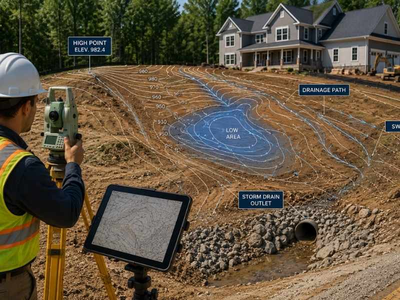
A topographic survey shows exactly where rainwater will travel across a lot, long before the first storm tests it. Every lot has a slope, even when it looks flat to the eye. The survey measures these slopes in close detail. It marks elevation points all across the property. Builders use this data to predict where water will move. Without this map, a builder is only guessing. The land can behave very differently during a real storm. A guess that misses the mark can show up months later.
Finding Low Areas Before They Turn Into Wet Spots
A topographic survey catches small dips in the ground long before they turn into standing water problems. These dips are easy to miss during a quick walk through a lot. They might only be a few inches deep, but that is still enough to hold water after a storm. Once a builder spots a dip on the map, the next steps become clear. Builders generally choose from three options:
- Fill the low area with soil
- Regrade so water flows away
- Route a drain through the area
Catching a small dip on paper costs far less than fixing it later.
Why the Ground Around a House Matters
A topographic survey gives builders the exact grades they need to keep water moving away from the foundation instead of toward it. The land right next to a house needs to slope away from the foundation. If the ground tilts the wrong way, water pools against the walls. This happens every time it rains. Builders often follow a grading rule from the International Residential Code. This rule says the ground must drop at least six inches over the first ten feet. Getting this detail right protects the home for decades. Getting it wrong often leads to costly foundation repairs.
Planning Drainage Features Before Construction Starts
A topographic survey gives engineers the numbers they need to plan swales, culverts, and other drainage features correctly. Guesswork rarely produces a system that holds up during a heavy storm. Many engineers also pull rainfall numbers from a NOAA tool called Atlas 14. This tool tracks storm patterns by region. Skipping this step often leads to costly changes once construction starts.
Looking Beyond the Building Site for Water Problems
A topographic survey often maps the land around a lot too, not just the lot itself. Water rarely respects property line. Rain that falls on a neighboring lot can flow straight onto a new home site. A nearby hillside can do the same, even on a level site. One inch of rain falling on just one acre adds up to about twenty seven thousand gallons. That runoff has to go somewhere. A wider survey view helps builders understand where outside runoff is headed. They can prepare for it well before the first storm hits.
Frequently Asked Questions
What is a topographic survey?
A topographic survey shows the shape of the land, including slopes, hills, and low areas. It maps these features using exact elevation points across the property. Builders use this map to study the ground first.
Can a topographic survey help with drainage problems?
Yes. A topographic survey can show where water may collect or flow, which helps builders plan ahead. It catches problems on paper instead of in a finished yard.
Why do builders use a topographic survey?
Builders use a topographic survey to understand the land before grading, drainage work, and construction begin. The survey reveals slopes and low spots that affect water flow. This information helps builders avoid costly surprises later.
When should a topographic survey be done?
Builders usually order a topographic survey before construction starts so they can catch problems early. This gives them time to plan grading correctly. Waiting until after construction begins often costs more to fix.
Is a topographic survey useful for new home sites?
Yes. A topographic survey helps builders make smarter drainage decisions before homes are built. It also helps builders plan for water that flows in from nearby land.


