Residential Land Survey Issues That Can Delay a Fence, Shed, or Addition

Residential land survey in a backyard showing property markers and measurements before building a fence, shed, or home addition.

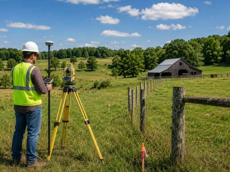
Most homeowners don’t think about a survey until a project is already started. By then, the delay had already begun. A residential land survey done before construction can catch problems early. Missing corners, unclear lines, old records, and permit requirements can all stop a project. Finding these issues early is much easier than dealing with them after a contractor is already scheduled.

Missing Corner Markers Can Stop a Project Before It Starts

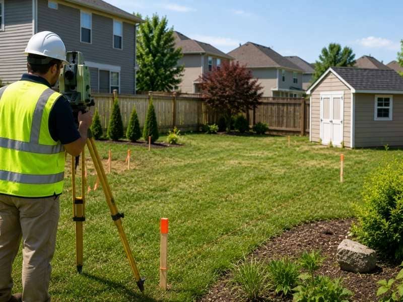
Corner markers show exactly where property lines meet. On older lots, those markers are often gone. Original iron pins or concrete posts set when the neighborhood was first built can get buried, paved over, or removed during yard work over the years.

When corners are missing, homeowners have no way to know exactly where their property lines are. Building a fence without confirmed corners means guessing. A fence built even a few inches onto a neighbor’s property creates a problem that costs time and money to fix. A residential land survey finds or replaces those corners so the project starts in the right spot.

Neighbor Disagreements About Property Lines Can Cause Delays

Disagreements between neighbors about where a boundary sits happen often. One homeowner thinks the line runs along an old fence. The neighbor has a different idea based on something a prior owner told them. Neither of those is a legal answer, and when one of them tries to build, the conflict shows up fast.

A residential land survey gives both sides something real to work from. It shows where the line is based on official records and field measurements. Starting a fence or addition without that information is a risk that often causes delays when a neighbor pushes back mid-construction.

Local Rules Can Limit Where a Structure Can Go

Local rules set minimum distances that structures must sit from property lines. These are called setbacks. A fence might be allowed close to the line, while a shed or addition needs to sit several feet back. Some homeowners associations have their own rules on top of local ones.

Without a current survey, homeowners don’t know exactly where their lines are. That makes it hard to confirm whether a planned structure meets the required distances. A survey gives the exact line locations needed to plan the project correctly. This helps avoid a permit rejection because the structure was placed too close to the line.

Old Property Records Can Point to the Wrong Location

Many residential lots have deeds and survey records that are very old. Some older records use reference points that no longer exist. A tree used as a corner marker may be gone. A road mentioned in the deed may have been moved years ago.

Relying on old records without checking them can send a project in the wrong direction. A homeowner who builds based on an old map may find out later that the information didn’t match current conditions. A current residential land survey checks what’s on the ground today against the recorded description. It finds any gaps before they become construction problems.

Missing Survey Documents Can Slow Down a Permit

Some permit applications require survey information before they move forward. A city or county building office may ask for a site plan that shows confirmed property lines. A homeowners association may need survey details before approving a new structure. Without a current survey, the application stalls while the homeowner tries to get one under time pressure.

Having a current residential land survey ready before submitting a permit saves time. It gives the reviewing office what it needs to process the application without sending it back. That can save weeks on a project that already has a contractor scheduled and materials ordered.

Frequently Asked Questions

What is a residential land survey?

A residential land survey shows where property lines and corners are located on a lot. It gives homeowners verified measurements based on field work and official records.

Why do I need a residential land survey before building a fence?

A survey confirms exactly where the property lines are so the fence gets built in the right place. Without it, there is no reliable way to know if the fence crosses into a neighbor’s property.

Can a residential land survey help with a shed or home addition?

Yes. A survey shows the exact property line locations needed to confirm that a planned shed or addition meets the required setback distances before construction starts.

Do I need a new residential land survey if I already have an old one?

Possibly. Older surveys may not reflect changes that have happened over time. A current survey gives accurate, verified information based on present conditions.

Can a residential land survey help settle a property line dispute?

Yes. A survey shows where the property lines are based on official records and field measurements. That gives neighbors a clear, factual answer to boundary questions.

Land Surveying Steps Buyers Should Take Before Closing on Rural Acreage

Land surveying on rural acreage with a surveyor measuring fence lines and property markers before closing.

Buying rural acreage is different from buying a house in a subdivision. The land is bigger, the boundaries are less obvious, and the details that matter most don’t show up in a listing. Land surveying gives buyers a clear picture of what they’re actually purchasing before the closing date arrives. Skipping it on rural property is one of the more expensive mistakes a buyer can make.

Check Property Lines Before You Buy

Rural properties often have long boundaries that run through wooded areas, across fields, or along creeks. Without a survey, buyers have no way to know exactly where those lines are. A listing may show a rough acreage number, but it won’t tell you where one owner’s land ends and the next one begins.

A land surveying professional places markers at the boundary corners and produces a map showing the exact lines. That information tells buyers what they’re getting and protects them if a neighbor ever questions where the property ends. On rural land especially, confirmed boundary lines are worth far more than assumptions.

Find Out if Anyone Else Has Rights to Use the Land

Owning land doesn’t always mean exclusive use of every part of it. Easements give other people or organizations legal rights to cross or use portions of a property. Utility companies may have the right to run power or gas lines through the land. A neighbor may have a recorded right to use a shared road that crosses the property. Access easements can affect where a buyer can build and what changes they can make.

A survey identifies these rights and shows where they sit on the property. Some easements are narrow and have little impact on everyday use. Others run through the most useful parts of the land and significantly affect future plans. Buyers deserve to know about all of them before closing, not after.

Make Sure Fences and Buildings Are in the Right Place

Rural properties often have fences, barns, sheds, storage buildings, and other structures. The important question is whether all of those features sit inside the property lines. Not every fence follows the actual boundary. Not every barn was placed with a survey in hand.

A land survey shows exactly where existing structures sit relative to the property lines. If a fence cuts inside the true boundary, the buyer may be getting less land than they think. If a barn sits partially outside the property line, it becomes a problem at closing or later when the buyer tries to sell. Finding these issues before closing gives buyers and sellers time to resolve them without pressure.

Confirm the Size and Features of the Property

An acreage number in a listing is a starting point. A survey gives buyers the verified measurement. On rural land, the difference between what a listing says and what a survey finds can sometimes be significant, especially on older parcels where the deed description hasn’t been checked against modern measurements in years.

Beyond the acreage, a survey can show features that affect how the land can be used. Creeks and drainage corridors affect where buildings can go. Wooded sections, open fields, and changes in terrain affect how the land performs for farming, hunting, or development. Knowing where those features sit on the property helps buyers plan realistically before they close.

Use Survey Results to Help With Closing

A completed survey is useful for more than just the buyer. Lenders often require a survey before approving financing on rural acreage. Title companies use survey information to confirm that the title is clear and that there are no boundary or encroachment issues that could affect the transaction. Having an accurate, current survey ready early in the process keeps things moving.

When survey results reveal an issue, addressing it before closing is far easier than addressing it after. A boundary discrepancy, an undisclosed easement, or a structure outside the property lines can all be worked through when there’s time and room to negotiate. Waiting until the last minute leaves buyers with fewer options and more pressure to accept terms they might otherwise question.

Frequently Asked Questions

Why is land surveying important before buying rural land?

A survey shows buyers where the property lines are, how much land they’re actually getting, and whether any easements or boundary issues could affect the property after closing.

Do I need a new land survey if the seller already has one?

Possibly. An older survey may not reflect recent changes to the property, new structures, or updated boundary information. A current survey gives buyers verified data based on present conditions.

Can land surveying show if there is a shared road or easement?

Yes. A survey identifies easements, shared access roads, and utility corridors that give other parties legal rights to use part of the property. Buyers should know about these before closing.

How long does land surveying take for rural acreage?

It depends on the size of the property and the terrain. Larger or heavily wooded tracts take more time to survey than smaller, open parcels. A surveying professional can give a time estimate based on the specific property.

Is land surveying worth it for vacant land?

Yes. Undeveloped land can still have boundary questions, easement issues, or structural encroachments from neighboring properties. A survey gives buyers the information they need to make a confident decision.

Survey Mapping Mistakes That Cost Developers Money

Surveyor reviewing plans and conducting survey mapping before site development begins

Most development projects don’t fail because of bad design or slow contractors. They stall because of bad survey mapping. A missed easement, a wrong boundary call, or an old base map can add weeks to a schedule and thousands to a budget before a single foundation is poured.

Survey mapping errors are common. They’re also preventable. Here’s what developers get wrong most often, and what it costs when those mistakes reach the field.

Ordering the Wrong Type of Survey for the Job

Not all surveys produce the same output. A lot survey and a topographic survey answer different questions. Ordering the wrong one wastes time and money, and it still leaves a gap in what your team needs.

Developers who skip the topographic survey and go straight into site design often find their grading plan doesn’t match the actual ground. The redesign costs more than the topo survey would have. On sloped or uneven sites, this mistake hits hard because every contour line affects where utilities go, where drainage flows, and where the building can sit.

Before ordering any survey, confirm with your engineer and architect which documents they need. Get that list in writing.

Using Outdated Survey Maps as the Base for Design

An old survey is not a current survey. A plat from ten years ago doesn’t show the fence a neighbor built six years ago, the widened driveway, or the rerouted utility line.

Developers who pull an old survey from the title file and hand it to their design team are taking a real risk. If conditions on the ground have changed, the design is built on wrong information. That problem shows up during construction, not during design. By then, fixing it costs far more.

If a survey is more than a few years old, or if anything has changed on the property or nearby parcels since it was done, order a new one. The cost is small compared to a mid-project correction.

When Lenders Flag Survey Age

Lenders and title companies have their own rules on how old a survey can be. Many won’t accept one older than six months to a year. If you’re working toward a construction loan, confirm the acceptable date range early. Finding out at closing that your survey is too old is a delay that didn’t need to happen.

Skipping the Records Research Phase

Survey mapping starts in the office, not in the field. A surveyor who goes straight to the site without pulling deed records, prior surveys, and recorded easements is doing partial work.

Records research finds problems a field visit can’t see. An access easement recorded in 1987 leaves no mark on the ground. A gap in the chain of title has no visible sign at the property corner. These issues only come out when someone looks for them in the public record.

Developers who push surveyors to skip deep research to save time often pay more later. A title issue that surfaces after closing becomes the developer’s problem to fix, and that fix is slow and expensive.

Survey Mapping Errors in Boundary Placement

Wrong boundary placement is the most costly survey mapping mistake on active construction projects. If a boundary line is off by even a few feet, structures end up in the wrong place, setbacks get violated, and neighboring parcels get affected.

This error is more common on sites where original survey monuments are missing or damaged. When a surveyor can’t find original markers, they have to rebuild the boundary from record documents and nearby evidence. That takes experience and careful work. Rushed jobs on tight deadlines produce poor results.

What Happens When a Boundary Is Wrong

A building placed over a property line or inside a neighbor’s setback doesn’t stay there. The municipality can require removal. The adjacent owner can take legal action. Title insurance may not cover the full cost if the survey that caused the problem was done improperly.

Fixing a boundary error after construction starts costs far more than getting it right before any digging begins. Require your surveyor to locate or set physical monuments at every corner before design work starts.

Not Verifying Easement Locations Before Site Design

Easements limit what you can build and where. A developer who doesn’t know exactly where an easement falls on a parcel before designing a building footprint will likely need to redesign after the survey maps it.

Utility easements, drainage easements, and access easements all remove buildable area. Some are narrow and easy to work around. Others cut through the most useful part of a lot. The design team needs that information at the start, not after a permit gets rejected.

Ask your surveyor to locate and map all recorded easements as part of the survey scope. Don’t rely on a deed reference alone. A deed may list an easement by book and page number without showing where it physically sits on your lot.

Treating Survey Mapping as a One-Time Step

Survey mapping is not just a pre-construction task. Some projects need updated surveys at more than one stage: before design, before permit submission, after rough grading, and after construction is complete.

An as-built survey at the end of a project shows what was actually built versus what was planned. Municipalities and lenders often require it before issuing a certificate of occupancy or releasing final loan funds. Developers who don’t plan for this step early are sometimes surprised by it at the worst possible time.

Build survey requirements into your project schedule from the start. Talk to your surveyor at the beginning about every survey document the job will need from start to finish.

Frequently Asked Questions

What is the most common survey mapping mistake on development projects? 

Using an outdated survey as the base for site design is the most common and costly mistake. Conditions on the ground change over time. A survey that doesn’t reflect current conditions will produce a design that doesn’t match reality in the field. Ordering a new survey at the start of every project prevents this.

How do survey mapping errors affect construction loans? 

Lenders require current, accurate surveys before funding. If survey errors come up during the lender’s review, the loan can be delayed. Boundary problems, missing easement disclosures, or surveys that don’t meet current standards can all trigger extra requirements that slow the closing process.

Can a developer be held liable for a survey mapping error? 

A developer who builds based on a survey they knew was outdated or incomplete takes on real liability. If that survey leads to an encroachment, setback violation, or title defect, the developer may face legal claims from adjacent owners, lenders, or the municipality. Always use a current, properly sealed survey from a licensed professional.

How does skipping records research affect a survey? 

Records research is how a surveyor finds easements, title gaps, and recorded restrictions that have no physical sign on the ground. A survey done without thorough records research is incomplete. These issues don’t disappear when they’re missed. They show up during permit review or title search.

When should a developer order an as-built survey? 

Order an as-built survey after construction is complete but before the final inspection. Most municipalities and lenders require it as part of project closeout. Planning for it at the start of the project, rather than treating it as a surprise at the end, keeps the schedule on track.