Why a Surveyor Reviews Abandoned Utility Lines Before Site Work

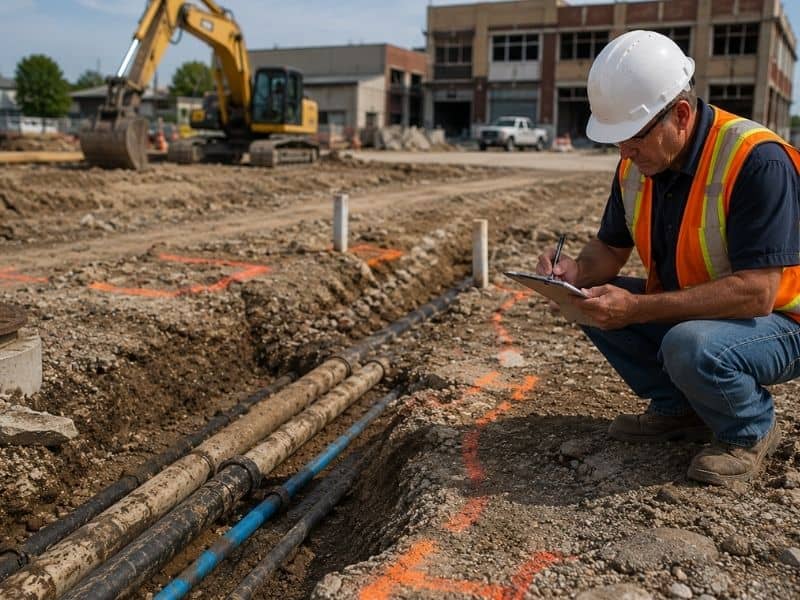
Surveyor inspecting exposed underground utility lines at a redevelopment construction site before site work begins

When a property gets ready for new construction, old pipes and wires sometimes hide beneath the ground. A surveyor plays a key role in finding these clues before crews start digging. A construction survey does more than mark property lines. It also checks for signs of utility lines that used to serve a building but may no longer be in use. Skipping this step can lead to costly delays, damaged equipment, or worse.

Why Abandoned Utility Lines Matter During Redevelopment

Older commercial and industrial sites often carry a long history. A building might have changed hands several times over the years. Each new business may have added its own water lines, gas pipes or electrical conduits. When a property gets redeveloped, some of these lines stay in the ground even after the equipment they served is long gone.

An inactive line doesn’t always mean an empty pipe. Sometimes a line still holds pressure. Sometimes a wire still carries a small electrical charge. Digging into one of these without warning can stop a project cold, or put a crew at risk.

Redevelopment sites carry more of this risk than open land does. A vacant lot rarely has decades of utility work buried underneath it. A site that once housed a factory, a gas station or a strip mall might have several old connections stacked on top of each other. That’s why a construction survey on a redevelopment site looks different from one on raw land. The survey team has to think about what used to be there, not just what sits there now.

How a Surveyor Investigates Signs of Old Utility Infrastructure

A surveyor doesn’t guess where old lines might sit. The work starts with a close look at the site itself. Manhole covers, valve boxes, pipe stubs and odd patches in the pavement can all point to something buried below.

Field crews walk the property and note anything that looks out of place. A patch of ground that settles differently than the rest, a small metal cap poking through the grass or a line marked on an old plan but missing from current maps can all be useful clues.

The surveyor’s job is to record what the evidence shows, not to decide what it means. Finding a pipe stub doesn’t prove a line is dead. It only proves a line once existed there. That distinction matters. A surveyor documents conditions so the project team can make an informed call, instead of assuming a quiet pipe is a safe one.

Comparing Historical Site Records With Current Field Conditions

Old site plans can tell a story the ground alone can’t. A surveyor working in Enterprise might pull permits, old utility maps or past records tied to the property’s earlier use.

These records get compared against what the crew actually sees on site today. A plan from thirty years ago might show a gas line running through what is now a parking lot. If that line doesn’t appear on any current utility map, it becomes a point worth flagging.

This step focuses on change over time. A property that once ran as a manufacturing plant and is now being turned into retail space will likely show gaps between old records and new conditions. Catching those gaps early gives the project team a chance to plan around them, instead of finding out the hard way once excavation starts.

What Old Utility Routes Can Mean for New Redevelopment Plans

Once a surveyor flags a suspected abandoned line, that information feeds straight into site planning. A building footprint drawn without this knowledge might sit right on top of an old gas line. A parking lot expansion could run straight through a forgotten electrical conduit.

Design teams use survey findings to shift plans before construction begins. Sometimes that means moving a proposed foundation a few feet. Other times it means routing new utilities around an old path rather than through it.

This kind of planning saves time and money later on. Redesigning around a legacy line on paper costs far less than stopping a crew mid excavation because a machine just struck something unexpected. For a property with a long history, mapping these old routes early keeps the redevelopment schedule on track.

When Survey Findings Need Follow-Up Before Excavation

A survey can point to a problem, but it can’t always solve one. If a surveyor documents signs of a suspected abandoned line, that finding often needs a next step before anyone breaks ground.

Confirming whether a line is truly out of service isn’t part of a surveyor’s role. That confirmation usually comes from the utility company or a specialist who can test the line directly. A surveyor’s job ends at documenting what the evidence shows and passing that information along to the project team.

Skipping this follow-up is a common mistake on redevelopment projects. A line that looks abandoned on paper can still be active underground. Coordinating with the right specialist before excavation starts protects the crew, the schedule and the budget all at once.

Frequently Asked Questions

What can a surveyor identify about abandoned utility lines? 

A surveyor can document visible evidence, mapped locations and other site clues tied to older utility infrastructure. This documentation doesn’t prove a line is inactive. It simply records what the survey found so the project team can review it.

Why should abandoned utility lines be reviewed before redevelopment work?

Legacy infrastructure can sit right beneath a planned foundation, parking area or excavation zone. Reviewing these lines before work begins helps avoid unexpected delays and damage once construction starts, especially on a property being converted to a new use.

Can a surveyor determine whether a utility line is still active? 

No. A surveyor can point out signs that a line may exist, but confirming whether it’s energized, pressurized or otherwise active usually falls to the utility provider or a qualified specialist. That confirmation sits outside the scope of a survey.

How can old utility records help a redevelopment project? 

Historical records can show where utility lines ran during a property’s earlier use. Comparing these records with current field conditions helps the project team spot gaps between what used to be there and what shows up today.

Should abandoned utility lines be investigated before excavation begins? 

Yes. Underground infrastructure that hasn’t been confirmed inactive shouldn’t be assumed safe. Addressing these questions during preconstruction planning gives the project team time to coordinate with the right specialist before any digging starts.
Surveyor Checks Before Turning a Single Lot Into Rental Homes

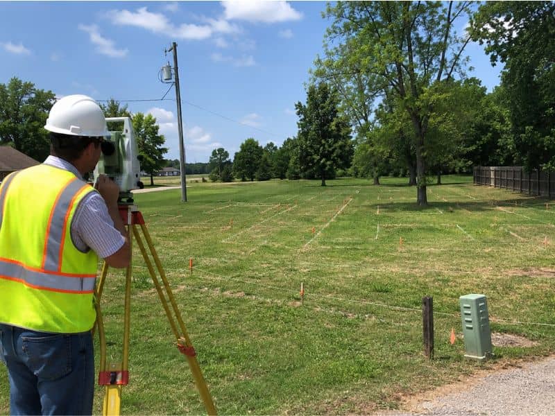
Surveyor mapping a single lot for multiple rental homes in Enterprise, Alabama.

A surveyor plays a big part in a new rental project. This is especially true in Enterprise, Alabama, where builders often turn one lot into several rental homes. You can’t just pick a few spots and start building right away. Someone has to measure the land first, then map out what’s already there. The whole plan has to work as one connected property, not a set of separate lots. Skip this step, and the project can run into serious trouble once construction is already underway. Here’s what a surveyor actually checks before that kind of rental project moves forward.

Confirm the Property Will Remain One Undivided Rental Parcel

Before anything else, a surveyor confirms exactly what kind of project this is. Several rental homes can sit on one piece of land under a single owner. The land never has to get split into separate lots. That’s different from a lot split, where the land gets divided into new, separate parcels with their own individual owners.

Getting this part right matters early on, since it shapes every decision that follows. The survey documents one legal piece of land, with all the rental homes planned to share that same property. If the land isn’t staying as one undivided parcel, the entire approach to the project changes.

Map Proposed Rental Home Footprints Across the Shared Site

Once the property is confirmed as one parcel, the survey helps determine where each rental home can realistically go. This means marking out the buildable area across the lot. It also means showing how each proposed home relates to the others sitting nearby.

Homes on a shared site can’t simply get placed wherever looks convenient at first glance. The survey lays out the actual usable space. This lets homes get positioned with enough room between them and a layout that flows sensibly across the property. This step focuses only on where the buildings sit. It doesn’t cover grading the land or planning new streets, since those pieces come later.

Check Building Separation and Shared-Space Dimensions

With building locations roughly set, the survey provides the measurements needed to review the space between them. That includes the distance between one rental home and the next. It also includes shared yards, walkways, parking areas, and any other outdoor space residents will use together.

These measurements matter because rental homes placed too close together can create cramped yards or tight parking. Walkways can end up barely functional too. A surveyor’s job here is providing exact numbers between the proposed features. It is not about settling disagreements over property lines or tracking down missing corner markers. That kind of work falls under a different type of survey entirely.

Document Existing Features That Affect the Rental Layout

Every lot already has something on it, even when it looks empty at first glance. A surveyor locates existing buildings, fences, and utility poles or boxes. Trees, paved driveways, and other physical features get documented too.

Some of these features might stay right where they are. Others might need removal to make room for the new rental homes. Either way, knowing what’s actually there matters before drawing up a layout. It keeps the design team from planning around something in the wrong spot. It also prevents missing a feature nobody noticed during a quick walk-through of the site.

Prepare a Survey Base for a Multi-Home Rental Site Plan

Everything gathered so far comes together into one survey. The parcel boundaries, the building footprints, the spacing, and the existing features all get combined. Architects, engineers, and developers then use that survey as a base for their plan.

Having one accurate base means the whole project team works from the same numbers. Nobody has to guess or measure things separately on their own. This step sets up a shared foundation for a layout involving multiple rental homes on a single property. It isn’t about commercial buildings or a different kind of legal survey. It also has nothing to do with dividing land into new lots, since none of that applies here.

Frequently Asked Questions

Can several rental homes be built on one parcel without dividing the land? 

It depends on local zoning rules, density limits, and other development regulations. A surveyor documents the parcel and its existing conditions. Local officials and design professionals then determine what type of rental development the site can actually support.

Is this the same as surveying a lot split? 

No, it’s different. This kind of survey applies when all the rental homes remain on one undivided property under common ownership. A lot split creates separate legal parcels instead. This survey supports the layout of multiple homes within a single, unified piece of land.

What site features should be shown for a multi-home rental project? 

Buildings, paved areas, fences, utility structures, trees, and access points typically need to be documented. Other visible improvements that could affect the layout matter too. The exact features shown should be defined clearly in the survey’s scope before fieldwork begins.

Does the surveyor decide where each rental home should be placed? 

Not directly. A surveyor provides accurate measurements and documents existing site conditions. Architects, engineers, developers, and local reviewing authorities then use that information to determine each home’s final placement.

When should the survey be ordered for a rental-home development? 

It should be obtained before the site plan and building layout get finalized. Early survey information helps the entire project team work from accurate property data. This beats relying on assumptions that might need correcting later.

Land Surveying Uses GPS

Land surveying is a profession that greatly utilize the GPS system.

ladn surveyingToday, man-made constellations are in orbit. Their purpose is to provide instant, exact and global positioning information. This global positioning system of GPS is revolutionizing the modern construction sites, automating and guiding land surveying equipment, providing instantaneous circles and volume gap, simplifying total and controlled surveys. Nearly everyone involved in the land surveying and construction industry has heard something about satellite positioning technology or maybe you or someone you know is already using it. Whether an operator or a casual observer, there are still many questions about how this exciting system really works.

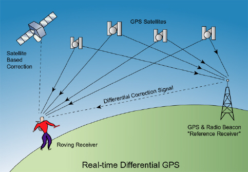
These positioning satellites don't stay in one place like the stars; they orbit the earth about twice a day. Constantly transmitting uniquely identified radio signals that can be perceived by specialized units on earth. These signals are used to precisely measure the distance to the receiving instrument from each satellite visibly overhead.

Just as stars have exact locations in the sky, the locations of the GPS satellites are also defined, becoming orbiting reference points. Using a process based on triangulation, a GPS receiver processes the signals from multiple satellites to compute an accurate position on Earth, which is why it is widely use in land surveying.

land surveyingFor mobile applications that require high accuracy, such as three dimensional machine control, there are two requirements that must be met. First, the signals from a minimum of five satellites must be received at all times. And second, those five satellites must be distributed across the sky. This is called Dilution of Precision or DOP. The simple rule of thumb is this, the more satellites received the better your system will perform.

All land surveying receivers incorporate standard GPS tracking technology; unfortunately the GPS satellite constellation alone cannot continuously make the minimum requirement of accurate mobile positioning. For any given location, there are times in a day when there are less than five available satellites or very poor DOP.

Now, consider a land surveying job site with trees, buildings, or other obstructions when satellite receptions are easily be further reduced. All land surveying GPS receivers suffer this same problem because they all use the same satellites to operate.

Even the planned signal modernization to the GPS satellites won't solve this problem. An obstruction that blocks one signal blocks all signals from that satellite. A land surveying equipment provider has solved this problem. The solution isn't adding more signals from the same satellites; it's adding more satellites.

Today, there is a second positioning satellite constellation in operation, the Glonass System. This positioning system is operated and maintained by the Russian government; much like the GPS is operated and maintained by the United States government; combining these two satellite constellations give land surveyors access to 38 different satellites; 14 more than a GPS-only system.

The additional satellites mean stronger and more accurate positions and better performance in obstructed land surveying areas. These additional satellites mean maximum up time in all land surveying locations, in all conditions.

For an up to date and accurate land surveying service, contact Enterprise Land Surveying at (888) 936-8426 or better yet, you may fill out our contact form request and a licensed land surveyor will contact you.