The Importance of Land Surveying in the Modern World

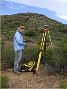
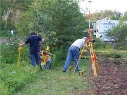
land surveyinngMost of you have probably never thought about land surveying until you needed it at some point. Many of us hear about land surveying all the time but never really give it much thought.

Since an investment in land and/or a home will likely be the largest investment you will ever make in your lifetime, knowing where your property lines are becomes very important indeed.

The art of land surveying was developed centuries ago. In fact, it’s one of the oldest professions in the world. The fact that it was used by man at such an early time and is still being used now shows how important surveying is to our survival.

Surveying land has many uses. Boundary surveying, for instance, allows you to know where your property corners or property lines are. This is especially helpful when disputes with a neighbour or with other people arise in terms of where your property ends.

If your family wants to divide a tract of land and transfer ownership to other family members, a boundary survey is the first step to do so. If you’re having a building constructed, it is very important that you have the land surveyed to make sure that you are not encroaching onto other peoples’ property.

A mistaken building location is very expensive to fix so you might as well invest in a boundary survey to prevent this.

"Land Surveying saves money, time, lives, and properties''.

A topographic survey, or topo survey for short, is another important type of land surveying. A topo survey is done to locate natural and man-made features on a particular parcel of land.

A topographic survey is different in that the elevation of the land is surveyed which means it can show man-made underground features, retaining walls, utility lines and etc.

Before you start any kind of construction activity, it’s important to have a topo survey done in the area so they’ll have an accurate record of the land’s existing conditions. Yes, that spot with the new mall in the neighbourhood had to have a topo survey done first.

Now, a flood survey or flood determination – this is very important too. It isn’t evident just looking at a property whether you are at risk of flooding or not. And, in some cases, even looking at the flood maps doesn’t give you an accurate answer.

The flood survey determines the elevation of the home and compares that to the base flood elevation. This is the only way to be sure you’re not in a flood hazard zone. If you’ve just been told that you live in a flood-prone area, having that confirmed by a professional land surveyor would let you know how to best proceed.

When getting flood insurance, insurance companies would require an elevation certificate from you. A land surveyor would be able to assist you with this.

If a company wants to invest in another state, or if there is a national lender on a commercial project, they will likely need an ALTA Land Title Survey done before anything is constructed. An ALTA Land Title Survey is a lot like a regular boundary survey except that nationally accepted ALTA Standards are used to guide the surveying effort.

Land surveying standards vary widely from state to state and an ALTA Land Title Survey is used to cut down on this variation. Also, an ALTA Land Title Survey typically is more involved than the state standards variety.

Because of this, an ALTA survey can be more anywhere from 50% to 200% more expensive than using the state standards only. If you need this type of survey, I suggest seeking an experienced land surveying company who is familiar with these additional requirements.

In summary, there are many uses for a land survey and for seeking the services of a land surveyor. If you’re unsure of your situation, consult Enterprise Land Surveying at (888)-936-8426 today or go to the Contact page and send us an email.

Welcome to Enterprise Land Surveying

Featured

Welcome to Enterprise Land Surveying's website

This site is intended to provide you with information on Land Surveying in the Enterprise, AL, Coffee and Dale Counties, and Geneva County area of Alabama. If you're looking for an Enterprise Land Surveyor, you've come to the right site. If you'd rather talk to someone about your land surveying needs, please call  (888) 936-8426 today. For more information, please continue to read.

enterprise land surveyingLand Surveyors are professionals who measure and make precise measurements to determine the size and boundaries of a piece of real estate.  While this is a simplistic definition, boundary surveying is one of the most common types of surveying related to home and land owners. If you fall into the following categories, please click on the appropriate link for more information on that subject:

Enterprise Land Surveying services:

  1. I need to know where my property corners or property lines are. (Boundary Survey)
  2. I have a loan closing or re-finance coming up on my home in a subdivision. (Lot Survey)
  3. I need a map of my property with contour lines to show elevation differences for my architect or engineer. (Topo Survey)
  4. I've just been told I'm in a flood zone or I 've been told I need an elevation certificate in order to obtain flood insurance or prove I don't need it. (Flood Survey)
  5. I'm purchasing a lot/house in a recorded subdivision. (Lot Survey – See Boundary Survey)
  6. I'm purchasing a larger tract of land, acreage, that hasn't been subdivided in the past. (Boundary Survey)

If your needs don't fall into one of the above, don't worry, we'll get to the bottom of it. CALL Enterprise Land Surveying TODAY at (888) 936-8426 OR better yet, fill out a Contact Form request to discuss your survey needs.

Land Surveying Uses GPS

Land surveying is a profession that greatly utilize the GPS system.

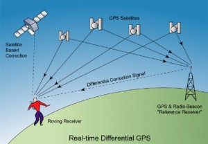
ladn surveyingToday, man-made constellations are in orbit. Their purpose is to provide instant, exact and global positioning information. This global positioning system of GPS is revolutionizing the modern construction sites, automating and guiding land surveying equipment, providing instantaneous circles and volume gap, simplifying total and controlled surveys. Nearly everyone involved in the land surveying and construction industry has heard something about satellite positioning technology or maybe you or someone you know is already using it. Whether an operator or a casual observer, there are still many questions about how this exciting system really works.

These positioning satellites don't stay in one place like the stars; they orbit the earth about twice a day. Constantly transmitting uniquely identified radio signals that can be perceived by specialized units on earth. These signals are used to precisely measure the distance to the receiving instrument from each satellite visibly overhead.

Just as stars have exact locations in the sky, the locations of the GPS satellites are also defined, becoming orbiting reference points. Using a process based on triangulation, a GPS receiver processes the signals from multiple satellites to compute an accurate position on Earth, which is why it is widely use in land surveying.

land surveyingFor mobile applications that require high accuracy, such as three dimensional machine control, there are two requirements that must be met. First, the signals from a minimum of five satellites must be received at all times. And second, those five satellites must be distributed across the sky. This is called Dilution of Precision or DOP. The simple rule of thumb is this, the more satellites received the better your system will perform.

All land surveying receivers incorporate standard GPS tracking technology; unfortunately the GPS satellite constellation alone cannot continuously make the minimum requirement of accurate mobile positioning. For any given location, there are times in a day when there are less than five available satellites or very poor DOP.

Now, consider a land surveying job site with trees, buildings, or other obstructions when satellite receptions are easily be further reduced. All land surveying GPS receivers suffer this same problem because they all use the same satellites to operate.

Even the planned signal modernization to the GPS satellites won't solve this problem. An obstruction that blocks one signal blocks all signals from that satellite. A land surveying equipment provider has solved this problem. The solution isn't adding more signals from the same satellites; it's adding more satellites.

Today, there is a second positioning satellite constellation in operation, the Glonass System. This positioning system is operated and maintained by the Russian government; much like the GPS is operated and maintained by the United States government; combining these two satellite constellations give land surveyors access to 38 different satellites; 14 more than a GPS-only system.

The additional satellites mean stronger and more accurate positions and better performance in obstructed land surveying areas. These additional satellites mean maximum up time in all land surveying locations, in all conditions.

For an up to date and accurate land surveying service, contact Enterprise Land Surveying at (888) 936-8426 or better yet, you may fill out our contact form request and a licensed land surveyor will contact you.