
A fence looks like a clear boundary. It runs along the yard, separates two properties, and gives everyone a sense of where one lot ends and the next begins. But fences are not legal property lines. A surveyor can measure a property and find that a fence sits several feet off from where the true line actually runs. This happens more often than most homeowners expect, and knowing what to do when it comes up makes the whole situation easier to handle.
Why Some Fences Do Not Follow the Property Line
Fences get built for many reasons. A prior owner may have put one up quickly without checking the official property records. Someone may have used an old stake or a landmark that seemed close enough at the time. In some cases, a handshake agreement between two neighbors years ago placed the fence where it seemed fair, not where the surveyed line was.
None of those methods produce a legal boundary. Only a licensed surveyor using official records and field measurements can establish where a property line truly sits. Over time, as properties change hands and memories fade, a fence built on rough estimates becomes something both sides treat as the real boundary. A survey is the only way to find out whether it actually is.
What a Surveyor Looks for When Checking a Fence
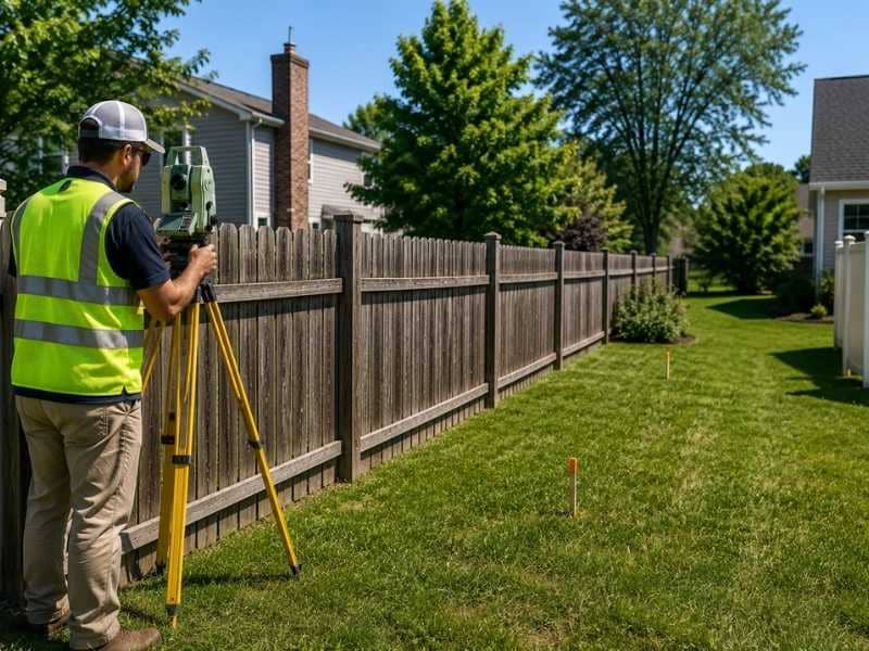
When a surveyor measures a property, they compare the fence location to the legal description recorded in the deed and the original plat. If the fence runs straight but the property line has an angle, those two won’t match. If a corner marker is missing or was placed incorrectly, the fence built from that marker will be off too.
Surveyors also look at how the fence connects to neighboring lines and whether the overall layout matches what the records show. A fence that curves or jogs in an unexpected spot may signal that whoever built it was working from incomplete information. The surveyor records exactly where the fence sits and exactly where the property line sits, so the difference between the two is clear.
What a Surveyor Does When a Fence Problem Is Found
When a surveyor finds that a fence doesn’t match the property line, they document it in the survey report. The report shows the location of the true property line and the location of the fence, along with the distance between them. That information is factual and based on measured data.
The surveyor’s job is to record what exists and where the line is. They don’t move fences or make legal decisions about what should happen next. But the survey report gives the homeowner a clear, documented picture of the situation. That document is what makes it possible to have an informed conversation with a neighbor or bring the information to a title company or attorney if needed.
Simple Ways Neighbors Can Handle Fence Questions
Finding out a fence is in the wrong spot doesn’t have to turn into a fight. In many cases, neighbors who see the survey results together can work out a simple solution without involving lawyers or courts. One neighbor may agree to adjust the fence. Both sides may decide to leave it in place and sign a written agreement that acknowledges the true property line.
Sharing the survey results calmly and giving the other party time to review them is a good first step. Most people respond better to a conversation that starts with facts than one that starts with accusations. A surveyor can also explain the findings directly to both parties if that helps. Clear information shared respectfully solves more fence problems than most homeowners expect.
Keeping Survey Records Can Help Avoid Future Problems
Once a survey is done and a fence question is resolved, keeping copies of all the survey documents is worth the effort. Those records show the true property line and document what was found and when. They become useful in several situations down the road.
When a homeowner wants to add a structure, sell the property, or apply for a permit, having a current survey on file speeds things up. Buyers and their lenders often ask for survey information during a sale, and having it ready avoids delays. If a new neighbor ever questions the boundary again, the existing survey provides a clear, dated answer. Good records prevent the same confusion from starting over with the next owner.
Frequently Asked Questions
Why would a surveyor find that a fence is not on the property line?
A fence may have been built using old information, rough measurements, or assumptions about where the boundary was. Only a licensed surveyor using official records can confirm where the true property line sits.
Can a surveyor tell if a fence is on the wrong property?
Yes. A surveyor measures the land and compares the fence location to the recorded legal description and plat. The survey report shows exactly where the fence sits relative to the true property line.
Does an old fence show the exact property line?
No. A fence shows where someone placed it, which may or may not match the true boundary. A survey provides the accurate, verified location of the property line.
What should I do if a surveyor finds a fence problem?
Review the survey results carefully and share them with your neighbor in a calm, straightforward way. Most fence questions can be worked out with good communication once both sides have the same accurate information.
Can a surveyor help prevent fence disputes in the future?
Yes. A survey provides clear boundary information based on official records and field measurements. Having that information documented helps homeowners avoid misunderstandings about property lines with current and future neighbors.

